National Permanent GNSS (Global Navigation Satellite Systems) Network
It consists of more than 20 permanent GPS/GNSS stations which data are archived, proceeded and analyzed in Center for procession and analysis. The procession and analysis of the measurements permits to carry out a monitoring of the current crustal motions in Bulgaria and Balkan Peninsula and, along with the seismic information, to evaluate the seismic risk.
Center for procession and analysis of GPS/GNSS measurements
The Center was established in 2002-2003 in connection with the obligations of the Department of Geodesy in the building and maintaining of the (new) State GPS network of the Republic of Bulgaria. Equipped with high technology computer techniques and possessing modern software for processing and analysis of GPS/GNSS measurements as: GAMIT/GLOBK, elaborated in the Massachusetts Technological Institute; Bernese 5.2, of the Astronomical Institute of the University of Bern, software packages QOCA, FONDA, DYNAPG.
In the Center are archived, proceeded and analyzed the measurements from the permanent GPS/GNSS stations on the territory of Bulgaria, Balkan Peninsula and Europe.
In Fig.1 are shown the permanent stations on the country’s territory which are proceeded regularly in the Center for analysis.
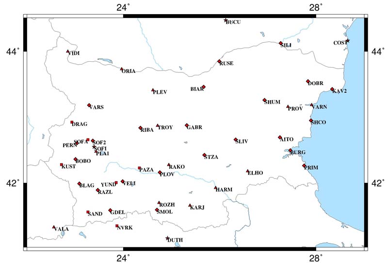
Fig.1
In the Figure with squares are marked the principal Hemus-NET permanent stations; with triangles the stations of the National GPS/GNSS Permanent Network of the National Institute of Geophysics, Geodesy and Geography (NIGGG) including the stations maintained together with NAVITEK Network; with lozenges are noted permanent stations of the NAVITEK Network; with stars are made EUREF permanent stations.
The first permanent stations of the National Permanent Network are settled in the mid of 2007 in the framework of the Project, financed in the Science for peace NATO program, “Monitoring of the deformation of the Earth’s crust in the Central-Western Bulgaria and Northern Greece with the Global positioning GPS – Hemus-NET.
The main permanent network Hemus-NET consists of 8 GPS/GNSS stations – 6 on Bulgarian territory and 2 on the territory of Greece:
The permanent GPS/GNSS stations are stabilized on the reinforced concrete posts.
Data from the permanent GPS/GNSS stations of the main permanent network Hemus-NET have free access at:
During the time from 2007 up to now NIGGG has installed considerable number of new permanent stations (see Fig. 1), united in a National Permanent GPS/GNSS Network – Hemus-NET.
The settled stations of the National network at the moment are:
Additionally will be installed a receiver in the mareographic station in Burgas from the National Mareographic Network.
With the intended three new stations in Tran and Pernik and the mareographic station in Burgas the total number of the permanent GPS/GNSS stations from the National Permanent GPS/GNSS Network – Hemus-NET is 26.
The permanent GPS/GNSS stations in Vidin, Oryahovo, Pleven, Kardzhali, Harmanli, Elhovo and Rakovski are installed and operated jointly with the permanent network NAVITEK, possession of SB Group. The data from all permanent GPS/GNSS stations of the network NAVITEK are given to NIGGG, according a binding contract, and are used for the research purposes of the National Institute (see Fig. 1).